
File:Chedul.jpg
Size of this preview: 800 × 531 pixels. Other resolutions: 320 × 213 pixels | 640 × 425 pixels | 1,024 × 680 pixels | 1,280 × 850 pixels | 2,560 × 1,700 pixels | 4,288 × 2,848 pixels.
Original file (4,288 × 2,848 pixels, file size: 7.86 MB, MIME type: image/jpeg)
Captions
Captions
Add a one-line explanation of what this file represents
Summary
[edit]| Description |
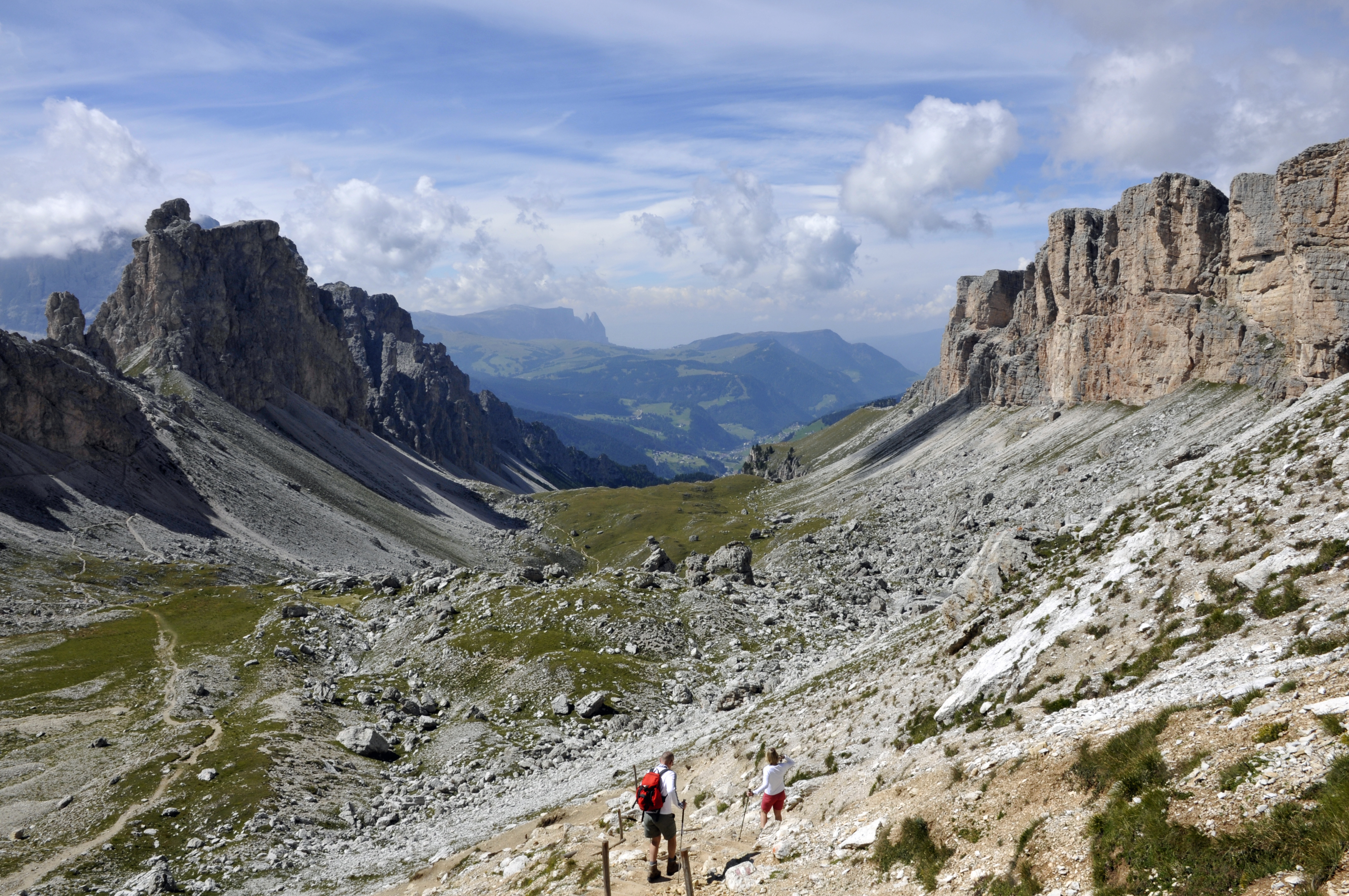
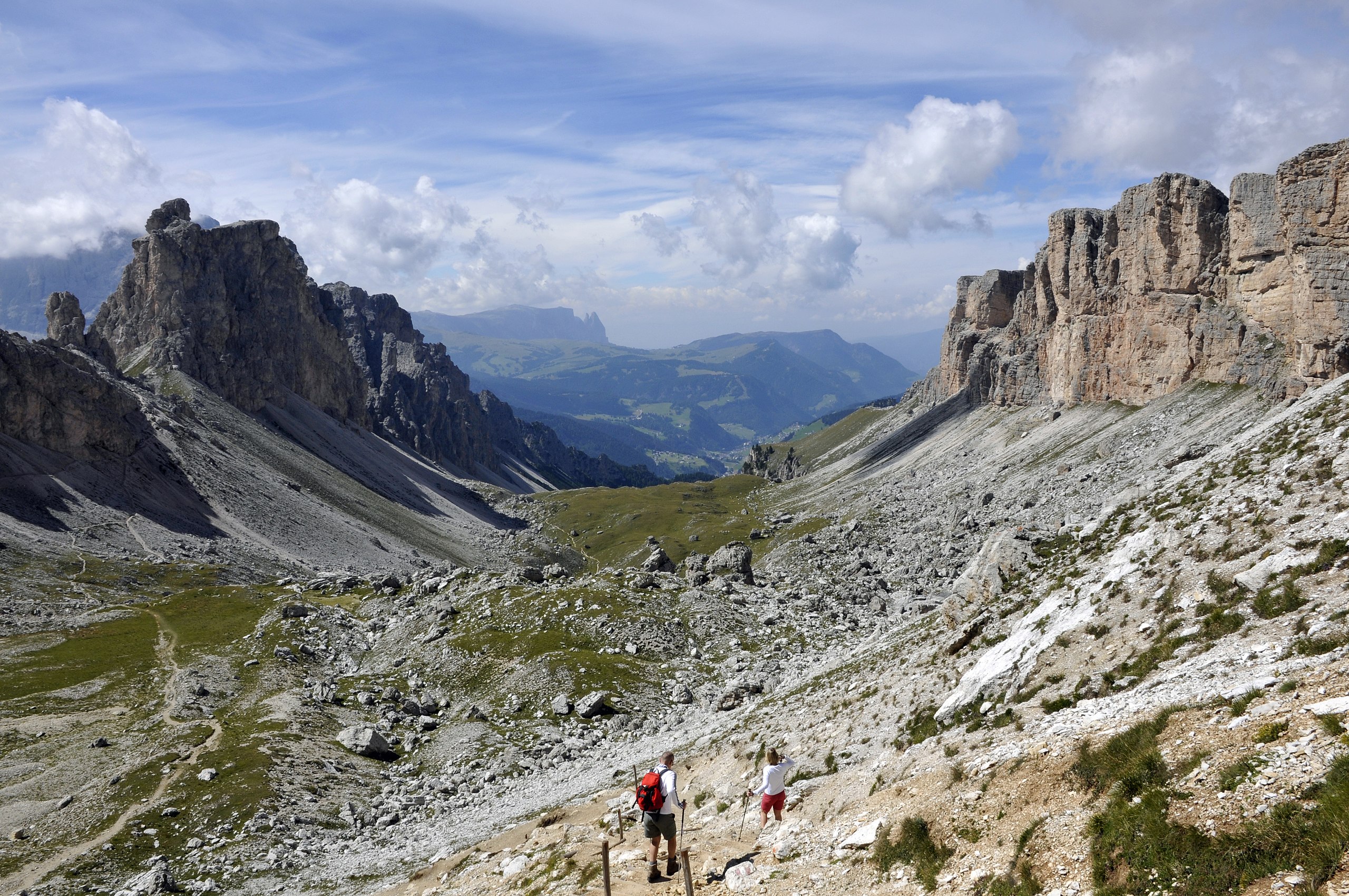
Deutsch: Das Chedul Tal mit den Cirspitzen links und den Mont de Sëura Stock rechts in Südtirol. Kommentar auf EB Exzellenter Bildaufbau; dank der hier sehr selten anzutreffenden Goldenen Spirale. Exzellente Farben. --Cornischong 20:24, 16. Nov. 2011 (CET)
|
||||||
| Date | |||||||
| Source | Own work | ||||||
| Author |
|

| Camera location | | View this and other nearby images on: OpenStreetMap |
|---|
Licensing
[edit]
I, the copyright holder of this work, hereby publish it under the following licenses:

|
Permission is granted to copy, distribute and/or modify this document under the terms of the GNU Free Documentation License, Version 1.2 or any later version published by the Free Software Foundation; with no Invariant Sections, no Front-Cover Texts, and no Back-Cover Texts. A copy of the license is included in the section entitled GNU Free Documentation License. |
| This file is licensed under the Creative Commons Attribution-Share Alike 3.0 Unported license. | ||
| ||
| This licensing tag was added to this file as part of the GFDL licensing update. |
| Copyleft: This work of art is free; you can redistribute it and/or modify it according to terms of the Free Art License. You will find a specimen of this license on the Copyleft Attitude site as well as on other sites. |
You may select the license of your choice.
| Annotations | This image is annotated: View the annotations at Commons |
This image has been assessed using the Quality image guidelines and is considered a Quality image.
|
File history
Click on a date/time to view the file as it appeared at that time.
| Date/Time | Thumbnail | Dimensions | User | Comment | |
|---|---|---|---|---|---|
| current | 18:17, 26 January 2011 | | 4,288 × 2,848 (7.86 MB) | Moroder (talk | contribs) | == {{int:filedesc}} == {{Information |Description= {{de|Die Cirspitzen, Chedul und links in Südtirol.}} {{en|The Cirspitzen is a mountain range in South Tyrol.}} |Source={{Own}} |
You cannot overwrite this file.
File usage on Commons
The following 8 pages use this file:
- User talk:Moroder/Archives 2012-1
- Commons:Featured picture candidates/File:Chedul.jpg
- Commons:Featured picture candidates/Log/December 2011
- Commons:Quality images/Subject/Places/Natural structures/archive 2008 to 2012
- Commons:Quality images candidates/Archives March 2012
- File:Chedul.jpg
- File:Lastëies Chedul Gherdëina.jpg
- File:Mont de seura chedul Cir.jpg
File usage on other wikis
The following other wikis use this file:
- Usage on de.wikipedia.org
- Usage on lld.wikipedia.org