File:Bishkek 03-2016 img51 Manas Airport.jpg

Original file (4,678 × 2,632 pixels, file size: 5.16 MB, MIME type: image/jpeg)
Captions
Captions
DescriptionBishkek 03-2016 img51 Manas Airport.jpg |
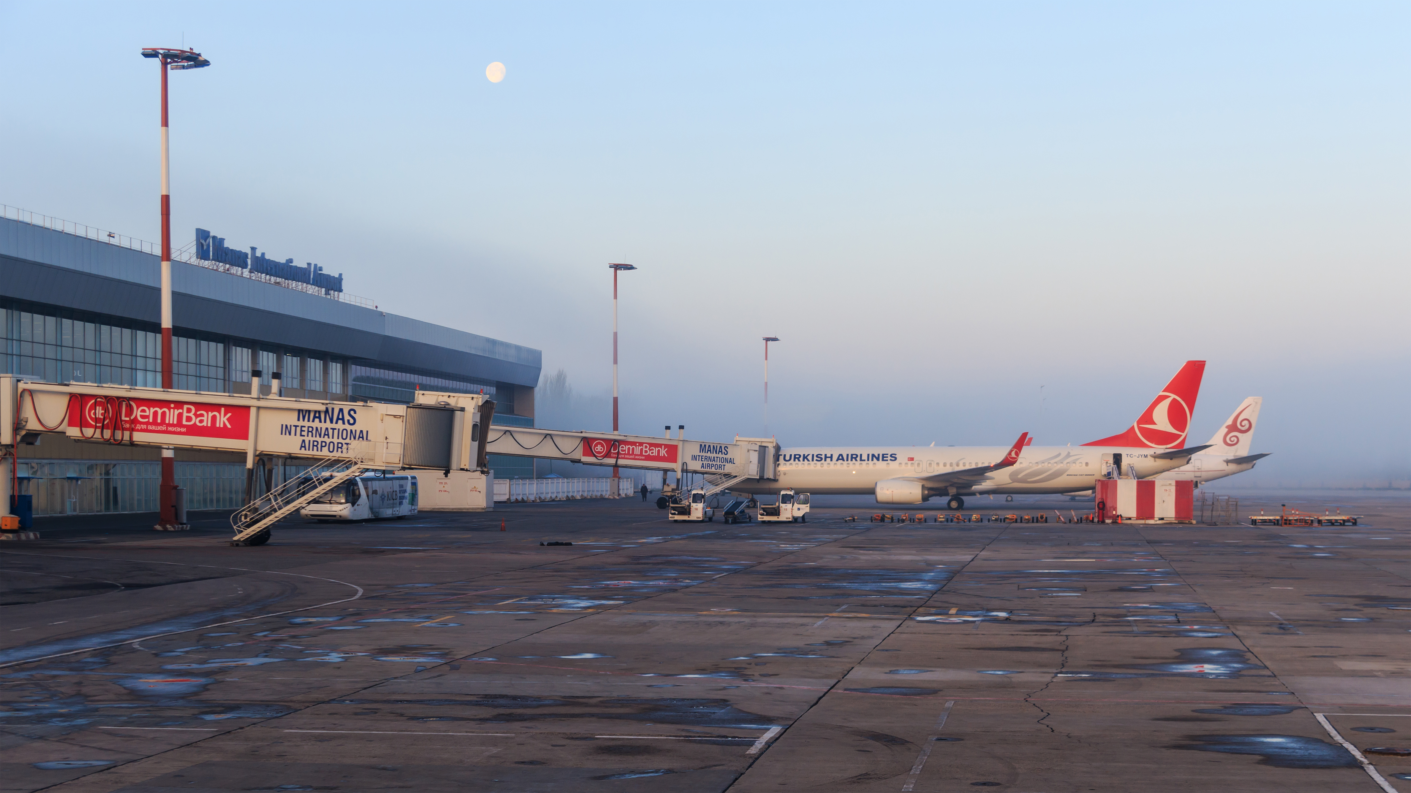
English: Manas International Airport in Bishkek, Kyrgyzstan. View behind the terminal building.
Русский: Международный аэропорт Манас в Бишкеке, Киргизия. Вид на заднюю сторону аэровокзала. |
Date | |
Source | Own work |
Author | A.Savin |
Permission (Reusing this file) |
Free Art License. Free usage of the photo; usually no need to ask for approval. Лицензия Свободное искусство. Использование фотографии бесплатно; согласование обычно не требуется. Lizenz Freie Kunst. Nutzung des Fotos kostenlos; Anfrage in der Regel nicht erforderlich.
Thank you. |
Camera location | 43° 03′ 20″ N, 74° 28′ 15″ E ![]() | View this and other nearby images on: OpenStreetMap | ![]() |
---|
![]() |
This image has been assessed using the Quality image guidelines and is considered a Quality image.
العربية ∙ جازايرية ∙ беларуская ∙ беларуская (тарашкевіца) ∙ български ∙ বাংলা ∙ català ∙ čeština ∙ Cymraeg ∙ Deutsch ∙ Schweizer Hochdeutsch ∙ Zazaki ∙ Ελληνικά ∙ English ∙ Esperanto ∙ español ∙ eesti ∙ euskara ∙ فارسی ∙ suomi ∙ français ∙ galego ∙ עברית ∙ हिन्दी ∙ hrvatski ∙ magyar ∙ հայերեն ∙ Bahasa Indonesia ∙ italiano ∙ 日本語 ∙ Jawa ∙ ქართული ∙ кыргызча ∙ 한국어 ∙ kurdî ∙ Latina ∙ Lëtzebuergesch ∙ lietuvių ∙ македонски ∙ മലയാളം ∙ मराठी ∙ Bahasa Melayu ∙ Nederlands ∙ Norfuk / Pitkern ∙ polski ∙ português ∙ português do Brasil ∙ qaraqalpaqsha ∙ rumantsch ∙ română ∙ русский ∙ sicilianu ∙ slovenčina ∙ slovenščina ∙ shqip ∙ српски / srpski ∙ svenska ∙ தமிழ் ∙ తెలుగు ∙ ไทย ∙ Tagalog ∙ toki pona ∙ Türkçe ∙ українська ∙ Oʻzbekcha ∙ vèneto ∙ Tiếng Việt ∙ 中文 ∙ 中文(简体) ∙ 中文(繁體) ∙ +/− |
Licensing
[edit]![]() |
Copyleft: This work of art is free; you can redistribute it and/or modify it according to terms of the Free Art License. You will find a specimen of this license on the Copyleft Attitude site as well as on other sites. http://artlibre.org/licence/lal/enFALFree Art Licensefalsetrue |
File history
Click on a date/time to view the file as it appeared at that time.
Date/Time | Thumbnail | Dimensions | User | Comment | |
---|---|---|---|---|---|
current | 22:52, 13 June 2016 | ![]() | 4,678 × 2,632 (5.16 MB) | A.Savin (talk | contribs) | {{User:A.Savin/F |Description= {{en|Manas International Airport in Bishkek, Kyrgyzstan. View behind the terminal building.}} {{ru|Международный аэропорт Манас в Бишкеке, Киргизия. Вид на заднюю ст... |
You cannot overwrite this file.
File usage on Commons
The following 5 pages use this file:
File usage on other wikis
The following other wikis use this file:
- Usage on ar.wikipedia.org
- Usage on ba.wikipedia.org
- Usage on bg.wikipedia.org
- Usage on ca.wikipedia.org
- Usage on ceb.wikipedia.org
- Usage on cy.wikipedia.org
- Usage on de.wikipedia.org
- Usage on de.wikivoyage.org
- Usage on en.wikipedia.org
- Usage on en.wikivoyage.org
- Usage on et.wikipedia.org
- Usage on fa.wikipedia.org
- Usage on fi.wikipedia.org
- Usage on fr.wikipedia.org
- Usage on fr.wikivoyage.org
- Usage on ha.wikipedia.org
- Usage on he.wikipedia.org
- Usage on hi.wikipedia.org
- Usage on hr.wikipedia.org
- Usage on hu.wikipedia.org
- Usage on id.wikipedia.org
- Usage on it.wikipedia.org
- Usage on it.wikivoyage.org
- Usage on ja.wikipedia.org
- Usage on ko.wikipedia.org
- Usage on ms.wikipedia.org
- Usage on nl.wikipedia.org
- Usage on pl.wikipedia.org
- Usage on pl.wikivoyage.org
- Usage on pt.wikipedia.org
- Usage on ro.wikipedia.org
- Usage on ru.wikipedia.org
- Usage on sv.wikipedia.org
- Usage on tr.wikipedia.org
- Usage on ur.wikipedia.org
- Usage on vi.wikipedia.org
- Usage on vi.wikivoyage.org
- Usage on www.wikidata.org
- Usage on zh.wikipedia.org
Metadata
This file contains additional information such as Exif metadata which may have been added by the digital camera, scanner, or software program used to create or digitize it. If the file has been modified from its original state, some details such as the timestamp may not fully reflect those of the original file. The timestamp is only as accurate as the clock in the camera, and it may be completely wrong.
Camera manufacturer | Canon |
---|---|
Camera model | Canon EOS 7D Mark II |
Author | A.Savin |
Copyright holder |
|
Exposure time | 1/100 sec (0.01) |
F-number | f/3.5 |
ISO speed rating | 100 |
Date and time of data generation | 07:20, 26 March 2016 |
Lens focal length | 35 mm |
Latitude | 43° 2′ 58.77″ N |
Longitude | 74° 28′ 43.02″ E |
Altitude | 20.8 meters above sea level |
Width | 5,472 px |
Height | 3,648 px |
Bits per component |
|
Pixel composition | RGB |
Orientation | Normal |
Number of components | 3 |
Horizontal resolution | 300 dpi |
Vertical resolution | 300 dpi |
Software used | Adobe Photoshop CC (Windows) |
File change date and time | 00:37, 14 June 2016 |
Exposure Program | Normal program |
Exif version | 2.3 |
Date and time of digitizing | 07:20, 26 March 2016 |
APEX shutter speed | 6.643856 |
APEX aperture | 3.61471 |
APEX exposure bias | 0 |
Maximum land aperture | 3 APEX (f/2.83) |
Metering mode | Pattern |
Flash | Flash did not fire, compulsory flash suppression |
DateTimeOriginal subseconds | 52 |
DateTimeDigitized subseconds | 52 |
Color space | sRGB |
Focal plane X resolution | 6,086.7630700779 |
Focal plane Y resolution | 6,090.1502504174 |
Focal plane resolution unit | inches |
Custom image processing | Normal process |
Exposure mode | Auto exposure |
White balance | Auto white balance |
Scene capture type | Standard |
GPS time (atomic clock) | 01:20:7.566 |
Satellites used for measurement | 20 |
Receiver status | Measurement in progress |
Measurement mode | 2-dimensional measurement |
Measurement precision | Good (23.7) |
Reference for direction of image | Magnetic direction |
Geodetic survey data used | WGS-84 |
GPS date | 26 March 2016 |
GPS tag version | 0.0.3.2 |
Serial number of camera | 033021000431 |
Lens used | 17-50mm |
Date metadata was last modified | 02:37, 14 June 2016 |
Unique ID of original document | 28F328312C0B91AFFCCF74C71474A77A |
IIM version | 4 |
Structured data
Items portrayed in this file
depicts
26 March 2016
43°3'20.002"N, 74°28'14.999"E
image/jpeg
e986e1fbff1c586805f2b0089f1b5d0cf30ab84d
5,407,224 byte
2,632 pixel
4,678 pixel
100
0.01 second
3.5
35 millimetre
- Photographs by A.Savin taken in 2016
- Photographs by A.Savin/Kyrgyzstan
- Files with coordinates missing SDC location of creation
- Quality images
- Quality images missing SDC creator
- FAL
- Taken with Canon EOS 7D Mark II
- Taken with Tamron SP AF 17-50mm F2.8
- Kyrgyzstan photographs taken on 2016-03-26
- Quality images of airplanes
- Quality images of airports
- Quality images of vehicles in Kyrgyzstan
- Quality images of transport in Bishkek