File:Bad Mitterndorf Tauplitzalm Sturzhahn NSGStmk 017.jpg

Original file (5,608 × 3,865 pixels, file size: 6.18 MB, MIME type: image/jpeg)
Captions
Captions
Summary
[edit]DescriptionBad Mitterndorf Tauplitzalm Sturzhahn NSGStmk 017.jpg |
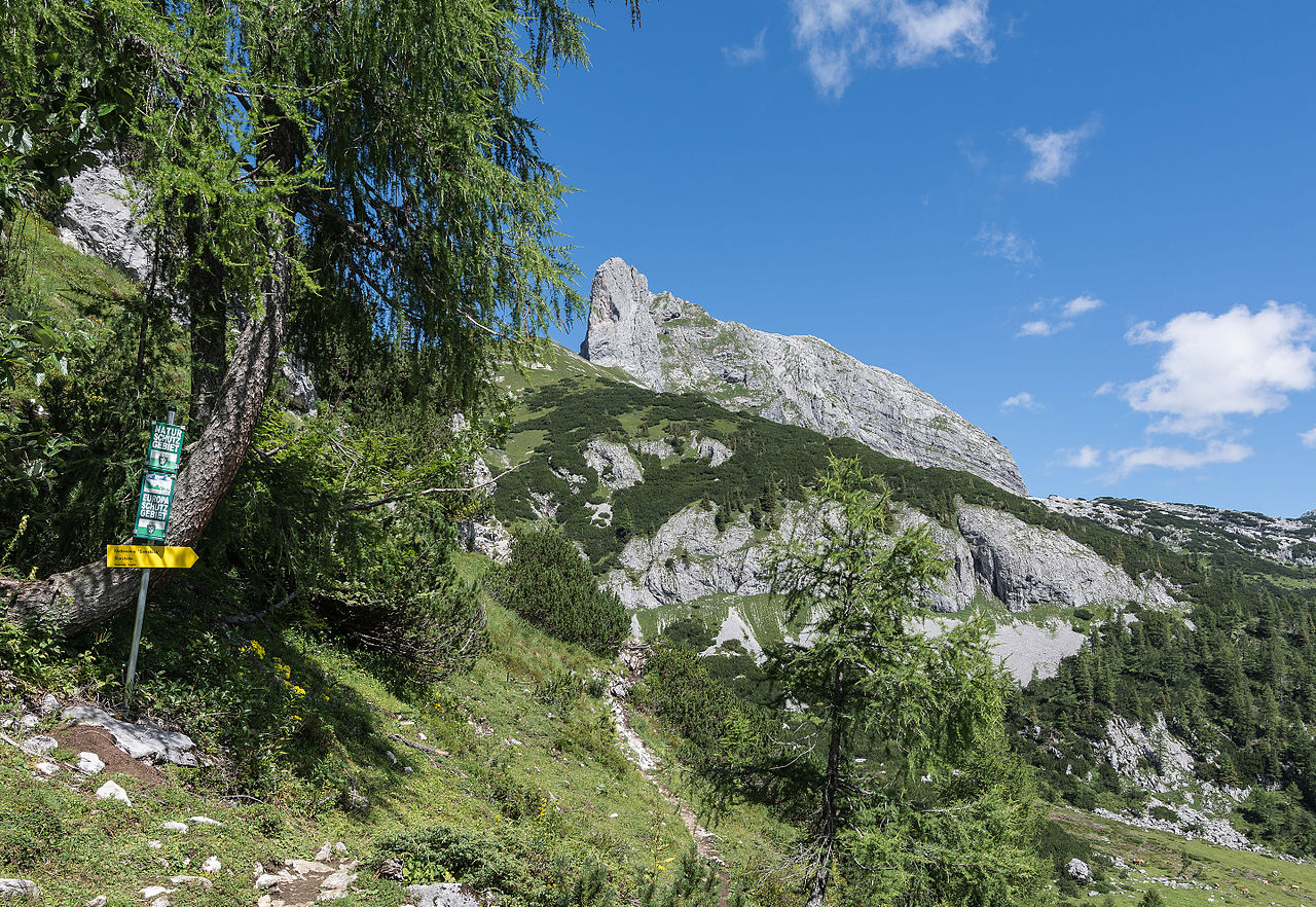
Deutsch: Der Sturzhahn (2028 m) ist ein Kletterberg am Rande der Tauplitzalm. English: The Sturzhahn (2028 m) is a peak for climbers at the border of Tauplitzalm/Styria. |
Date | |
Source | Own work |
Author | Isiwal |
Camera location | 47° 35′ 53.46″ N, 14° 01′ 08.38″ E ![]() | View this and other nearby images on: OpenStreetMap | ![]() |
---|
Licensing
[edit]


- You are free:
- to share – to copy, distribute and transmit the work
- to remix – to adapt the work
- Under the following conditions:
- attribution – You must give appropriate credit, provide a link to the license, and indicate if changes were made. You may do so in any reasonable manner, but not in any way that suggests the licensor endorses you or your use.
- share alike – If you remix, transform, or build upon the material, you must distribute your contributions under the same or compatible license as the original.
![]() |
The making of this work was supported by Wikimedia Austria. For other files made with the support of Wikimedia Austria, please see the category Supported by Wikimedia Österreich. |
Annotations InfoField | This image is annotated: View the annotations at Commons |
Sturzhahn (2028 m)
![]() |
This image has been assessed using the Quality image guidelines and is considered a Quality image.
العربية ∙ جازايرية ∙ беларуская ∙ беларуская (тарашкевіца) ∙ български ∙ বাংলা ∙ català ∙ čeština ∙ Cymraeg ∙ Deutsch ∙ Schweizer Hochdeutsch ∙ Zazaki ∙ Ελληνικά ∙ English ∙ Esperanto ∙ español ∙ eesti ∙ euskara ∙ فارسی ∙ suomi ∙ français ∙ galego ∙ עברית ∙ हिन्दी ∙ hrvatski ∙ magyar ∙ հայերեն ∙ Bahasa Indonesia ∙ italiano ∙ 日本語 ∙ Jawa ∙ ქართული ∙ Qaraqalpaqsha ∙ 한국어 ∙ kurdî ∙ кыргызча ∙ Latina ∙ Lëtzebuergesch ∙ lietuvių ∙ македонски ∙ മലയാളം ∙ मराठी ∙ Bahasa Melayu ∙ Nederlands ∙ Norfuk / Pitkern ∙ polski ∙ português ∙ português do Brasil ∙ rumantsch ∙ română ∙ русский ∙ sicilianu ∙ slovenčina ∙ slovenščina ∙ shqip ∙ српски / srpski ∙ svenska ∙ தமிழ் ∙ తెలుగు ∙ ไทย ∙ Tagalog ∙ toki pona ∙ Türkçe ∙ українська ∙ oʻzbekcha / ўзбекча ∙ vèneto ∙ Tiếng Việt ∙ 中文 ∙ 中文(简体) ∙ 中文(繁體) ∙ +/− |
File history
Click on a date/time to view the file as it appeared at that time.
Date/Time | Thumbnail | Dimensions | User | Comment | |
---|---|---|---|---|---|
current | 16:41, 4 August 2015 | ![]() | 5,608 × 3,865 (6.18 MB) | Isiwal (talk | contribs) | VicuñaUploader 1.20 |
You cannot overwrite this file.
File usage on Commons
The following 3 pages use this file:
Metadata
This file contains additional information such as Exif metadata which may have been added by the digital camera, scanner, or software program used to create or digitize it. If the file has been modified from its original state, some details such as the timestamp may not fully reflect those of the original file. The timestamp is only as accurate as the clock in the camera, and it may be completely wrong.
Camera manufacturer | NIKON CORPORATION |
---|---|
Camera model | NIKON D7100 |
Exposure time | 1/200 sec (0.005) |
F-number | f/8 |
ISO speed rating | 100 |
Date and time of data generation | 12:25, 3 August 2015 |
Lens focal length | 16 mm |
Latitude | 47° 35′ 53.46″ N |
Longitude | 14° 1′ 8.38″ E |
City shown | Tauplitz |
Horizontal resolution | 240 dpi |
Vertical resolution | 240 dpi |
Software used | Adobe Photoshop Lightroom 5.7 (Windows) |
File change date and time | 21:37, 3 August 2015 |
Exposure Program | Aperture priority |
Exif version | 2.3 |
Date and time of digitizing | 12:25, 3 August 2015 |
APEX shutter speed | 7.643856 |
APEX aperture | 6 |
APEX exposure bias | 0 |
Maximum land aperture | 4 APEX (f/4) |
Metering mode | Pattern |
Light source | Unknown |
Flash | Flash did not fire, compulsory flash suppression |
DateTimeOriginal subseconds | 80 |
DateTimeDigitized subseconds | 80 |
Focal plane X resolution | 2,558.641204834 |
Focal plane Y resolution | 2,558.641204834 |
Focal plane resolution unit | 3 |
Sensing method | One-chip color area sensor |
File source | Digital still camera |
Scene type | A directly photographed image |
Custom image processing | Normal process |
Exposure mode | Auto exposure |
White balance | Auto white balance |
Digital zoom ratio | 1 |
Focal length in 35 mm film | 24 mm |
Scene capture type | Standard |
Scene control | None |
Contrast | Normal |
Saturation | Normal |
Sharpness | Normal |
Subject distance range | Unknown |
GPS tag version | 0.0.2.2 |
Serial number of camera | 4369452 |
Lens used | 16.0-35.0 mm f/4.0 |
Date metadata was last modified | 23:37, 3 August 2015 |
Unique ID of original document | 44E6460CE438FB5C27A2962C6CA599A8 |
Province or state shown | Steiermark |
Country shown | Österreich |
IIM version | 4 |
Structured data
Items portrayed in this file
depicts
3 August 2015
47°35'53.4599"N, 14°1'8.3820"E
image/jpeg
9a2bd4d1d6d020ac6de215b050cb5d7dce5d2246
6,476,470 byte
3,865 pixel
5,608 pixel
100
0.005 second
16 millimetre
- Nature reserves in Austria with known ID
- Files with coordinates missing SDC location of creation
- CC-BY-SA-4.0
- Self-published work
- Supported by Wikimedia Österreich
- Uploaded with VicuñaUploader
- Quality images of Styria
- Quality images by Isiwal
- Images with annotations
- Quality images
- Quality images missing SDC depicts