
File:Bergtocht van S-charl naar Alp Sesvenna. 10-09-2019. (d.j.b) 25.jpg

Size of this preview: 800 × 533 pixels. Other resolutions: 320 × 213 pixels | 640 × 427 pixels | 1,024 × 683 pixels | 1,280 × 853 pixels | 2,560 × 1,707 pixels | 5,184 × 3,456 pixels.
Original file (5,184 × 3,456 pixels, file size: 18.36 MB, MIME type: image/jpeg)
Captions
Captions
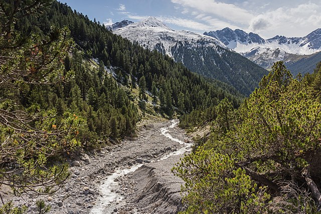
Mountain stream Aval S-charl, tributary of the Clemgia, seeking a way through the rubble of an erosion field
Summary
[edit]_25.jpg&action=edit§ion=1)
| Description |
Nederlands: Bergtocht van S-charl een plaats in het Zwitserse kanton Graubünden naar Alp Sesvenna. Bergbeek Aval S-charl, zijrivier van de Clemgia. Wandeltochten vanuit Val Sinestra (1474 meter), in het Unterengadin in Graubünden, Zwitserland.
English: Mountain tour from S-charl a place in the Swiss canton Graubünden to Alp Sesvenna. Mountain stream Aval S-charl, tributary of the Clemgia. Walking tours from Val Sinestra (1474 meters), in Unterengadin in Graubünden, Switzerland.
Español: Arroyo de montaña y afluente del río Clemgia (cuenca del río Eno) en el Val S-charl, Cantón de los Grisones, Suiza.
Українська: Гірський тур від села S-charl — місця у швейцарському кантоні Граубюнден до хребта Сесвенна. Гірський потік Аваль, притока Клемджі (басейн Інн). |
| Date | |
| Source | Own work |
| Author | Dominicus Johannes Bergsma |
| Other versions |
_26.jpg) |
| Camera location | | View this and other nearby images on: OpenStreetMap |
|---|
_25.jpg¶ms=046.728716_N_0010.352011_E_globe:Earth_type:camera__&language=en)
Licensing
[edit]_25.jpg&action=edit§ion=2)
I, the copyright holder of this work, hereby publish it under the following license:
This file is licensed under the Creative Commons Attribution-Share Alike 4.0 International license.
- You are free:
- to share – to copy, distribute and transmit the work
- to remix – to adapt the work
- Under the following conditions:
- attribution – You must give appropriate credit, provide a link to the license, and indicate if changes were made. You may do so in any reasonable manner, but not in any way that suggests the licensor endorses you or your use.
- share alike – If you remix, transform, or build upon the material, you must distribute your contributions under the same or compatible license as the original.
Assessment
[edit]_25.jpg&action=edit§ion=3)
|
_25.jpg)
This image has been assessed using the Quality image guidelines and is considered a Quality image.
|
This image was selected as picture of the day on Wikimedia Commons for 19 July 2021. It was captioned as follows: English: Mountain stream between S-charl in the Swiss Grisons and Piz Sesvenna on the border with South Tyrol Other languages:
Čeština: Horský potok mezi vesnicí S-charl ve švýcarském kantonu Graubünden a horou Piz Sesvenna na hranicích s Jižním Tyrolskem. English: Mountain stream between S-charl in the Swiss Grisons and Piz Sesvenna on the border with South Tyrol Español: Arroyo de montaña y afluente del río Clemgia (cuenca del río Eno) en el Val S-charl, Cantón de los Grisones, Suiza. Magyar: Hegyi patak, a Clemgia mellékfolyója a Sesvenna-hegységben (Val S-charl, Graubünden kanton, Svájc) Nederlands: Bergbeek tussen S-charl, een plaatsje ten zuiden van Scuol in het Zwitserse kanton Graubünden, en de Piz Sesvenna, met 3204 meter de hoogste top van de Sesvennagroep Português: Córrego de montanha e afluente do rio Clemgia (bacia do rio Inn) no vale S-charl, Cantão dos Grisões, Suíça. Македонски: Планинска прошетка во кантонот Граубинден, Швајцарија. Українська: Гірський тур від села S-charl — місця у швейцарському кантоні Граубюнден до хребта Сесвенна. Гірський потік Аваль, притока Клемджі. |
File history
Click on a date/time to view the file as it appeared at that time.
| Date/Time | Thumbnail | Dimensions | User | Comment | |
|---|---|---|---|---|---|
| current | 05:30, 11 October 2019 | | 5,184 × 3,456 (18.36 MB) | Famberhorst (talk | contribs) | Vlek verwijderen. |
| 17:58, 2 October 2019 |  | 5,184 × 3,456 (17.23 MB) | Famberhorst (talk | contribs) | User created page with UploadWizard |
You cannot overwrite this file.
File usage on Commons
The following 32 pages use this file:
- User:Andrew J.Kurbiko/POTD/2021
- User:Famberhorst/Bergtochten in Graubünden, kanton in Zwitserland in 2019.
- User:Nardog/PotY/2019
- User talk:Famberhorst
- User talk:Famberhorst/Archive 27
- Commons:Featured picture candidates/File:Bergtocht van S-charl naar Alp Sesvenna. 10-09-2019. (d.j.b) 25.jpg
- Commons:Featured picture candidates/Log/October 2019
- Commons:Featured pictures/Places/Natural/Switzerland
- Commons:Featured pictures/chronological/2019-B
- Commons:Picture of the Year/2019/Candidates
- Commons:Picture of the Year/2019/R1/Gallery/2019-B
- Commons:Picture of the Year/2019/R1/Gallery/ALL
- Commons:Picture of the Year/2019/R1/Gallery/M10
- Commons:Picture of the Year/2019/R1/Gallery/Nature views
- Commons:Picture of the Year/2019/R1/v/Bergtocht van S-charl naar Alp Sesvenna. 10-09-2019. (d.j.b) 25.jpg
- Commons:Quality images/Subject/Places/Natural structures/archive 2019
- Commons:Quality images candidates/Archives October 07 2019
- File:Bergtocht van S-charl naar Alp Sesvenna. 10-09-2019. (d.j.b) 26.jpg
- Template:Potd/2021-07
- Template:Potd/2021-07-19
- Template:Potd/2021-07-19 (ar)
- Template:Potd/2021-07-19 (cs)
- Template:Potd/2021-07-19 (en)
- Template:Potd/2021-07-19 (es)
- Template:Potd/2021-07-19 (fr)
- Template:Potd/2021-07-19 (hu)
- Template:Potd/2021-07-19 (mk)
- Template:Potd/2021-07-19 (myv)
- Template:Potd/2021-07-19 (nl)
- Template:Potd/2021-07-19 (pt)
- Template:Potd/2021-07-19 (pt-br)
- Template:Potd/2021-07-19 (uk)
_25.jpg)
File usage on other wikis
The following other wikis use this file:
- Usage on alt.wikipedia.org
- Usage on av.wikipedia.org
- Usage on be-tarask.wikipedia.org
- Usage on crh.wikipedia.org
- Usage on cv.wikipedia.org
- Usage on de.wikivoyage.org
- Usage on fr.wikipedia.org
- Usage on hu.wikipedia.org
- Usage on hy.wikipedia.org
- Usage on it.wiktionary.org
- Usage on ka.wikipedia.org
- Usage on ko.wikipedia.org
- Usage on lbe.wikipedia.org
- Usage on lez.wikipedia.org
- Usage on mk.wikipedia.org
- Usage on os.wikipedia.org
- Usage on pms.wikisource.org
- Usage on pt.wikipedia.org
- Usage on ru.wikipedia.org
- Usage on ru.wikinews.org
- Usage on sah.wikipedia.org
- Usage on uk.wikipedia.org
- Usage on vep.wikipedia.org
- Usage on zh.wikipedia.org
_25.jpg&oldid=1001841530)