
File:Naajaat panorama 2007-08-09 2 cropped USM downsampled edit.jpg

Size of this preview: 800 × 172 pixels. Other resolutions: 320 × 69 pixels | 640 × 138 pixels | 1,024 × 220 pixels | 1,280 × 275 pixels | 5,224 × 1,124 pixels.
Original file (5,224 × 1,124 pixels, file size: 6.43 MB, MIME type: image/jpeg)
Captions
Captions
Add a one-line explanation of what this file represents
Summary
[edit]
| Description |
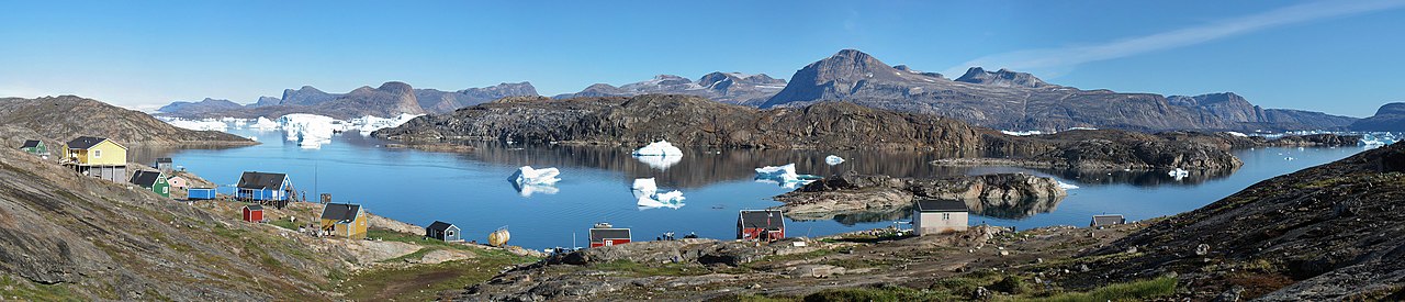
Dansk: Panorama ud over den lille nordvestgrønlandske bydg Naajaat. I baggrunden til venstre ses indlandsisen. Panoramaet er skabt i PTGui med Smartblend ud fra håndholdte billeder taget med et Canon IXUS 800 IS kompaktkamera.
English: Panorama of the small settlement Naajaat in North-West Greenland. The Greenland ice sheet is seen to the upper left. The panoramic is based on hand-held photos taken with a Canon IXUS 800 IS compact camera. The stiching was done in PTGui with Smartblend.
Español: Vista panorámica del pueblo de Naajaat en el noroeste de Groenlandia (9 de agosto de 2007). Se puede ver la capa de hielo en la parte superior izquierda.
Français : Le village de Naajaat dans le Nord-Ouest du Groenland. On peut voir la calotte glaciaire en haut à gauche. Image panoramique obtenue en utilisant PTGui à partir de photos réalisées avec un appareil photo digital compact Canon IXUS 800 IS.
Українська: Невеличке поселення Нааяат у північно-західній Ґренландії, 9 серпня, 2007. У лівому верхньому куті видно Ґренландський льодовиковий щит
Português: Vista panorâmica do assentamento de Naajaat no noroeste da Groenlândia (9 de agosto de 2007). Pode-se ver o manto de gelo no canto superior esquerdo.
Bosanski: Malehno naselje Naajaat na sjeverozapadu Grenlanda 9. augusta 2007. Na gornjem lijevo uglu vidljiv je i dio grenlandskog ledenog štita.
Čeština: Malá osada Naajaat v severozápadním Grónsku, 9. srpna, 2007. Na snímku nahoře vlevo je patrný Grónský ledovec.
Magyar: A nyugat-grönlandi Naajaat település látképe. Bal felső sarokban a grönlandi jégtakaró látható
|
| Date |
|
| Source | |
| Author |
|
| Camera location | | View this and other nearby images on: OpenStreetMap |
|---|
| This is a retouched picture, which means that it has been digitally altered from its original version. Modifications: Exposure clipping removed. The original can be viewed here: Naajaat panorama 2007-08-09 2 cropped USM downsampled.jpg:
|
This image was selected as picture of the day on Wikimedia Commons for 8 August 2015. It was captioned as follows: English: The small settlement Naajaat in Northwest Greenland, August 9, 2007. The Greenland ice sheet is seen to the upper left. Other languages:
Bosanski: Malehno naselje Naajaat na sjeverozapadu Grenlanda 9. augusta 2007. Na gornjem lijevo uglu vidljiv je i dio grenlandskog ledenog štita. Čeština: Malá osada Naajaat v severozápadním Grónsku, 9. srpna, 2007. Na snímku nahoře vlevo je patrný Grónský ledovec. English: The small settlement Naajaat in Northwest Greenland, August 9, 2007. The Greenland ice sheet is seen to the upper left. Español: Vista panorámica del pueblo de Naajaat en el noroeste de Groenlandia (9 de agosto de 2007). Se puede ver la capa de hielo en la parte superior izquierda. Magyar: A nyugat-grönlandi Naajaat település látképe. Bal felső sarokban a grönlandi jégtakaró látható Nederlands: De kleine nederzetting Naajaat in noordwest Groenland met linksachter in beeld de Groenlandse ijskap. Português: Vista panorâmica do assentamento de Naajaat no noroeste da Groenlândia (9 de agosto de 2007). Pode-se ver o manto de gelo no canto superior esquerdo. Українська: Невеличке поселення Нааяат у північно-західній Ґренландії, 9 серпня, 2007. У лівому верхньому куті видно Ґренландський льодовиковий щит |
|
Licensing
[edit]
I, the copyright holder of this work, hereby publish it under the following licenses:
This file is licensed under the Creative Commons Attribution-Share Alike 3.0 Unported, 2.5 Generic, 2.0 Generic and 1.0 Generic license.
- You are free:
- to share – to copy, distribute and transmit the work
- to remix – to adapt the work
- Under the following conditions:
- attribution – You must give appropriate credit, provide a link to the license, and indicate if changes were made. You may do so in any reasonable manner, but not in any way that suggests the licensor endorses you or your use.
- share alike – If you remix, transform, or build upon the material, you must distribute your contributions under the same or compatible license as the original.

|
Permission is granted to copy, distribute and/or modify this document under the terms of the GNU Free Documentation License, Version 1.2 or any later version published by the Free Software Foundation; with no Invariant Sections, no Front-Cover Texts, and no Back-Cover Texts. A copy of the license is included in the section entitled GNU Free Documentation License. |
You may select the license of your choice.
Original upload log
[edit]
This image is a derivative work of the following images:
- File:Naajaat_panorama_2007-08-09_2_cropped_USM_downsampled.jpg licensed with Cc-by-sa-3.0,2.5,2.0,1.0, GFDL
- 2010-02-27T01:17:30Z Noodle snacks 5224x1124 (6667230 Bytes) selective sharpen a spot.
- 2010-02-27T01:15:41Z Noodle snacks 5224x1124 (6667230 Bytes) restitch
- 2007-12-21T22:05:48Z Slaunger 5900x1200 (2083239 Bytes) {{Information |Description= {{da|Panorama ud over den lille nordvestgrønlandske bydg [[:da:Naajaat|Naajaat]]. I baggrunden til venstre ses indlandsisen.}} {{en|Panorama of the small settlement [[w:Naajaat|Naajaat]] in North-
Uploaded with derivativeFX
| Annotations | This image is annotated: View the annotations at Commons |
File history
Click on a date/time to view the file as it appeared at that time.
| Date/Time | Thumbnail | Dimensions | User | Comment | |
|---|---|---|---|---|---|
| current | 11:37, 28 February 2010 | 5,224 × 1,124 (6.43 MB) | Herbythyme (talk | contribs) | {{Information |Description={{da|Panorama ud over den lille nordvestgrønlandske bydg Naajaat. I baggrunden til venstre ses indlandsisen. Panoramaet er skabt i Hugin ud fra håndholdte billeder taget med et [[w:Canon |
You cannot overwrite this file.
File usage on Commons
The following 27 pages use this file:
- User:Slaunger/FPs
- User:Ö/Best/2010
- User talk:Slaunger/Archives/2010/11
- Commons:Featured picture candidates/File:Naajaat panorama 2007-08-09 2 cropped USM downsampled.jpg
- Commons:Featured picture candidates/Log/March 2010
- Commons:Featured pictures/Places/Panoramas
- Commons:Featured pictures/Places/Settlements
- Commons:Picture of the Year/2010/Galleries/Index/3
- Commons:Picture of the Year/2010/Galleries/Panoramas
- Commons:Picture of the Year/2010/Galleries/Panoramas/Large
- Commons:Picture of the Year/2010/Galleries/Panoramas/Small
- Commons:Picture of the Year/2010/R1/File:Naajaat panorama 2007-08-09 2 cropped USM downsampled edit.jpg
- File:Greenland Wikivoyage banner.jpg
- Template:Potd/2015-08
- Template:Potd/2015-08-08
- Template:Potd/2015-08-08 (bs)
- Template:Potd/2015-08-08 (cs)
- Template:Potd/2015-08-08 (en)
- Template:Potd/2015-08-08 (es)
- Template:Potd/2015-08-08 (hu)
- Template:Potd/2015-08-08 (it)
- Template:Potd/2015-08-08 (ko)
- Template:Potd/2015-08-08 (nl)
- Template:Potd/2015-08-08 (pt)
- Template:Potd/2015-08-08 (ru)
- Template:Potd/2015-08-08 (uk)
- Category:Naajaat
File usage on other wikis
The following other wikis use this file:
- Usage on be-tarask.wikipedia.org
- Usage on bg.wikipedia.org
- Usage on bn.wikipedia.org
- Usage on ca.wikipedia.org
- Usage on ceb.wikipedia.org
- Usage on crh.wikipedia.org
- Usage on cs.wikipedia.org
- Usage on cv.wikipedia.org
- Usage on da.wikipedia.org
- Usage on de.wikipedia.org
- Usage on en.wikipedia.org
- Naajaat
- Wikipedia:Featured pictures/Places/Panorama
- User:Slaunger
- Talk:Naajaat
- User talk:Slaunger
- Wikipedia:Featured pictures thumbs/22
- Wikipedia:Featured picture candidates/Naajaat
- Wikipedia:Featured picture candidates/March-2010
- Wikipedia:Wikipedia Signpost/2010-03-08/Features and admins
- Upernavik Archipelago
- User talk:JJ Harrison/Archive3
- Wikipedia:Picture of the day/October 2011
- Template:POTD/2011-10-17
- Wikipedia:Main Page history/2011 October 17
- Portal:Islands/Selected picture
- Portal:Islands/Selected picture/8
- Wikipedia:Wikipedia Signpost/Single/2010-03-08
- Usage on en.wikiversity.org
- Usage on es.wikipedia.org
- Usage on fa.wikipedia.org
- Usage on fr.wikipedia.org
- Usage on hu.wikipedia.org
- Usage on ilo.wikipedia.org
- Plantilia:Napili a ladawan ita nga aldaw/Agosto 5
- Plantilia:Napili a ladawan ita nga aldaw/Oktubre 5
- Plantilia:Napili a ladawan ita nga aldaw/Disiembre 5
- Plantilia:Napili a ladawan ita nga aldaw/Pebrero 5
- Plantilia:Napili a ladawan ita nga aldaw/Abril 5
- Plantilia:Napili a ladawan ita nga aldaw/Hunio 5
- Usage on it.wikipedia.org
- Usage on iu.wikipedia.org
- Usage on ka.wikipedia.org
- Usage on kl.wikipedia.org
- Usage on ko.wikipedia.org
View more global usage of this file.