
File:Wind Turbines and Power Lines, East Sussex, England - April 2009.jpg

Size of this preview: 800 × 386 pixels. Other resolutions: 320 × 155 pixels | 640 × 309 pixels | 1,024 × 494 pixels | 1,280 × 618 pixels | 2,560 × 1,236 pixels | 8,190 × 3,955 pixels.
Original file (8,190 × 3,955 pixels, file size: 7.67 MB, MIME type: image/jpeg)
Captions
Captions
Add a one-line explanation of what this file represents
Summary
[edit]| Description |
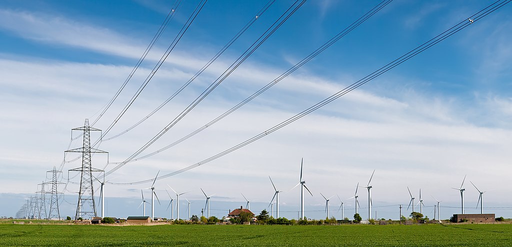
English: A windfarm and electricity pylons/power lines near Rye, East Sussex, England. The 400 kV power lines are from Dungeness Nuclear Power Station, which is just visible on the skyline behind the pylons.
Français : Un champs d'éoliennes et des pylônes électriques de Lignes à haute tension (400 kV) près de Rye dans le Sussex de l'Est, en Angleterre.
Deutsch: Eine 400-kV-Freileitungstrasse vor einem Windpark nahe Rye, Süd Sussex, England. Die Stromleitung führt zur Dungeness Nuclear Power Station, die auch klein am Horizont zu erkennen ist. |
| Date | before 27 April 2009 |
| Source | Own work |
| Author | Diliff |
| Permission (Reusing this file) |
Summary:In using this image or any subsequent derivatives of it, you are required to release the image under the same license. As such, any reproduction of this image, in any medium, must appear with a copy of, or full URL of the license.Attribution of this image to the author (DAVID ILIFF) is also required, preferably in a prominent location near the image.No other conditions may be added to, or removed from this license without the permission of the author and copyright holder.Suggested attribution: "Photo by DAVID ILIFF. License: https://creativecommons.org/licenses/by-sa/3.0/"Please review the full license requirements carefully before using this image. If you would like to clarify the terms of the license or negotiate less restrictive commercial licensing outside of the bounds of GFDL/CC-BY-SA, please contact me by email, or if you don't have a Wikipedia account you can either leave a message on my talk page with your contact details and your request, or you can contact me on Facebook. Please also send a 'friend request' to ensure that I am aware of your message. |
| Camera location | | View this and other nearby images on: OpenStreetMap |
|---|
Licensing
[edit]I, the copyright holder of this work, hereby publish it under the following licenses:
This file is licensed under the Creative Commons Attribution-Share Alike 3.0 Unported license.
- You are free:
- to share – to copy, distribute and transmit the work
- to remix – to adapt the work
- Under the following conditions:
- attribution – You must give appropriate credit, provide a link to the license, and indicate if changes were made. You may do so in any reasonable manner, but not in any way that suggests the licensor endorses you or your use.
- share alike – If you remix, transform, or build upon the material, you must distribute your contributions under the same or compatible license as the original.

|
Permission is granted to copy, distribute and/or modify this document under the terms of the GNU Free Documentation License, Version 1.2 or any later version published by the Free Software Foundation; with no Invariant Sections, no Front-Cover Texts, and no Back-Cover Texts. A copy of the license is included in the section entitled GNU Free Documentation License. |
You may select the license of your choice.
|

This image has been assessed using the Quality image guidelines and is considered a Quality image.
|
File history
Click on a date/time to view the file as it appeared at that time.
| Date/Time | Thumbnail | Dimensions | User | Comment | |
|---|---|---|---|---|---|
| current | 21:15, 26 April 2009 | | 8,190 × 3,955 (7.67 MB) | Diliff (talk | contribs) | {{Information |Description={{en|1=A windfarm and electricity pylons/power lines near Rye, East Sussex, England.}} |Source=Own work by uploader |Author=Diliff |Date= |Permission={{Diliff/Licensing}} |other_versions= }} {{location dec|50.975 |
You cannot overwrite this file.
File usage on Commons
The following 24 pages use this file:
- England
- User:Julia W/Diliff gallery
- User:Ö/Best/2009
- User talk:Diliff/Archive1
- User talk:Diliff/Archive2
- User talk:Julia W/Archive 1
- Commons:Featured picture candidates/File:Wind Turbines and Power Lines, East Sussex, England - April 2009.jpg
- Commons:Featured picture candidates/Log/June 2009
- Commons:Featured pictures/Objects
- Commons:Featured pictures/chronological/2009-A
- Commons:Files used on the OpenStreetMap Wiki/29
- Commons:Picture of the Year/2009/Galleries/2009-A
- Commons:Picture of the Year/2009/Galleries/All
- Commons:Picture of the Year/2009/Galleries/Index/8
- Commons:Picture of the Year/2009/Galleries/Index/Objects
- Commons:Picture of the Year/2009/Galleries/Objects
- Commons:Picture of the Year/2009/Galleries/Objects/2
- Commons:Picture of the Year/2009/Galleries/Table/200906
- Commons:Picture of the Year/2009/R1/File:Wind Turbines and Power Lines, East Sussex, England - April 2009.jpg
- Commons:Picture of the Year/2009/Results/R1/ALL/Table
- Commons:Picture of the Year/2009/Results/R1/Objects
- Commons:Picture of the Year/2009/Results/R1/Objects/Table
- Commons:Quality images/Subject/Objects/Electronics & electrical/archive 2008 to 2020
- Commons:Quality images candidates/Archives September 2009
File usage on other wikis
The following other wikis use this file:
- Usage on de.wikipedia.org
- Usage on de.wikiversity.org
- Usage on en.wikipedia.org
- Usage on fr.wikipedia.org
- Usage on hr.wikipedia.org
- Usage on pl.wikipedia.org
- Usage on ru.wikipedia.org
- Usage on su.wikipedia.org
- Usage on vi.wikipedia.org