File:2017 Dwór barokowy w Długopolu Górnym 1.jpg

Original file (3,503 × 2,460 pixels, file size: 6.43 MB, MIME type: image/jpeg)
Captions
Captions
Summary
[edit]Description2017 Dwór barokowy w Długopolu Górnym 1.jpg |
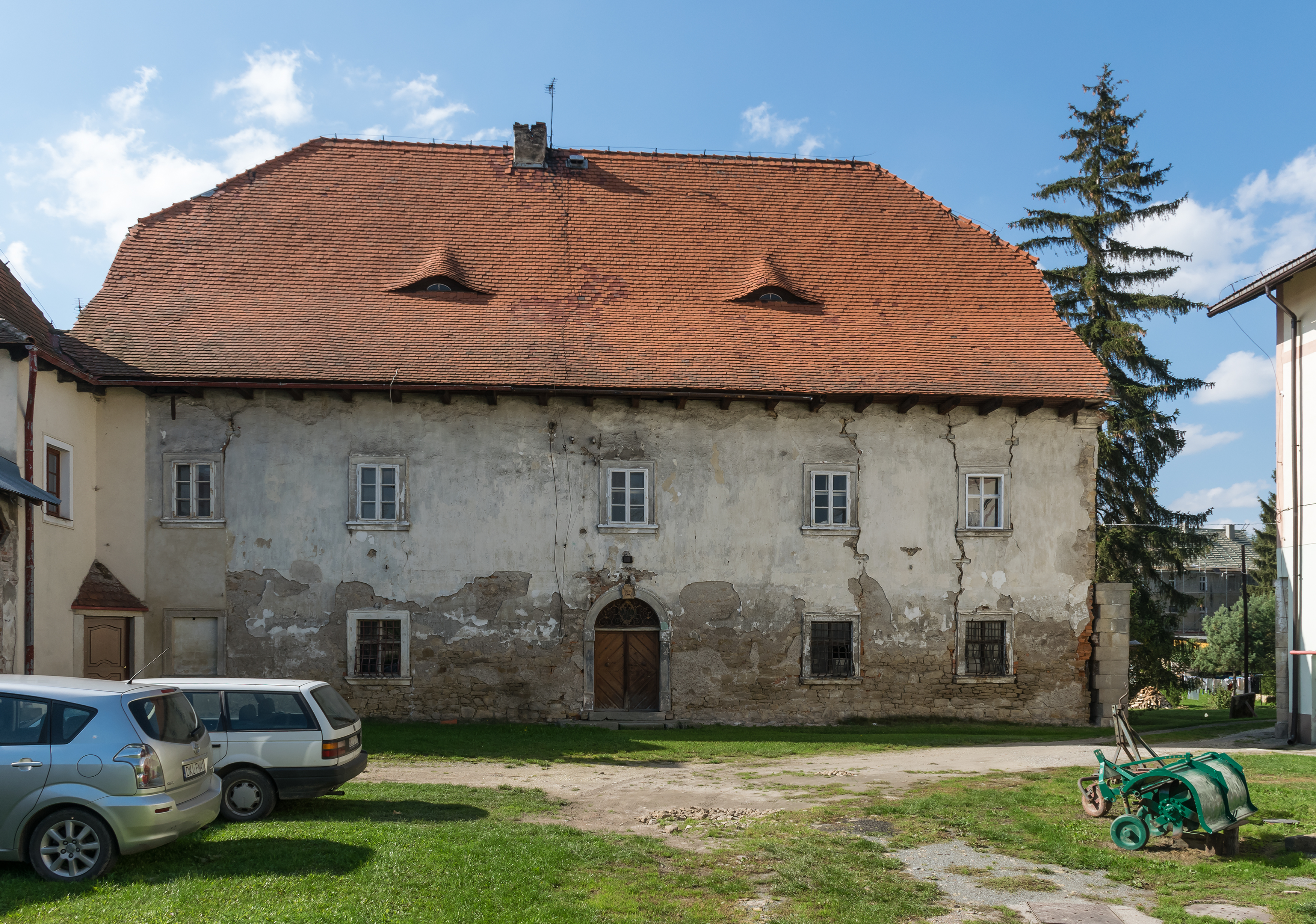
Polski: Dwór barokowy w Długopolu Górnym
English: Baroque manor in Długopole Górne
|
||
Date | |||
Source | Own work | ||
Author | Jacek Halicki |
Object location | 50° 13′ 16.85″ N, 16° 38′ 52.33″ E ![]() | View this and other nearby images on: OpenStreetMap | ![]() |
---|
Licensing
[edit]

- You are free:
- to share – to copy, distribute and transmit the work
- to remix – to adapt the work
- Under the following conditions:
- attribution – You must give appropriate credit, provide a link to the license, and indicate if changes were made. You may do so in any reasonable manner, but not in any way that suggests the licensor endorses you or your use.
![]() |
This image was uploaded as part of WikiVacations contest in Poland.
বাংলা | Deutsch | English | italiano | македонски | Nederlands | polski | português do Brasil | українська | +/− |
![]() |
![]() |
This image was uploaded as part of Wiki Loves Monuments 2017.
Afrikaans ∙ Alemannisch ∙ العربية ∙ جازايرية ∙ azərbaycanca ∙ Bikol Central ∙ беларуская ∙ беларуская (тарашкевіца) ∙ български ∙ বাংলা ∙ brezhoneg ∙ bosanski ∙ català ∙ čeština ∙ Cymraeg ∙ dansk ∙ Deutsch ∙ Zazaki ∙ Ελληνικά ∙ English ∙ Esperanto ∙ español ∙ eesti ∙ euskara ∙ فارسی ∙ suomi ∙ français ∙ Frysk ∙ Gaeilge ∙ galego ∙ עברית ∙ हिन्दी ∙ hrvatski ∙ magyar ∙ հայերեն ∙ Bahasa Indonesia ∙ Ido ∙ italiano ∙ 日本語 ∙ ქართული ∙ 한국어 ∙ кыргызча ∙ Lëtzebuergesch ∙ latviešu ∙ Malagasy ∙ македонски ∙ മലയാളം ∙ Bahasa Melayu ∙ Malti ∙ norsk bokmål ∙ नेपाली ∙ Nederlands ∙ norsk nynorsk ∙ norsk ∙ polski ∙ português ∙ português do Brasil ∙ română ∙ русский ∙ sicilianu ∙ davvisámegiella ∙ slovenčina ∙ slovenščina ∙ shqip ∙ српски / srpski ∙ svenska ∙ ไทย ∙ Tagalog ∙ Türkçe ∙ українська ∙ اردو ∙ oʻzbekcha / ўзбекча ∙ Yorùbá ∙ 中文 ∙ 中文(中国大陆) ∙ 中文(简体) ∙ 中文(繁體) ∙ 中文(香港) ∙ 中文(臺灣) ∙ +/− |
![]() |
![]() |
This image has been assessed using the Quality image guidelines and is considered a Quality image.
العربية ∙ جازايرية ∙ беларуская ∙ беларуская (тарашкевіца) ∙ български ∙ বাংলা ∙ català ∙ čeština ∙ Cymraeg ∙ Deutsch ∙ Schweizer Hochdeutsch ∙ Zazaki ∙ Ελληνικά ∙ English ∙ Esperanto ∙ español ∙ eesti ∙ euskara ∙ فارسی ∙ suomi ∙ français ∙ galego ∙ עברית ∙ हिन्दी ∙ hrvatski ∙ magyar ∙ հայերեն ∙ Bahasa Indonesia ∙ italiano ∙ 日本語 ∙ Jawa ∙ ქართული ∙ кыргызча ∙ 한국어 ∙ kurdî ∙ Latina ∙ Lëtzebuergesch ∙ lietuvių ∙ македонски ∙ മലയാളം ∙ मराठी ∙ Bahasa Melayu ∙ Nederlands ∙ Norfuk / Pitkern ∙ polski ∙ português ∙ português do Brasil ∙ qaraqalpaqsha ∙ rumantsch ∙ română ∙ русский ∙ sicilianu ∙ slovenčina ∙ slovenščina ∙ shqip ∙ српски / srpski ∙ svenska ∙ தமிழ் ∙ తెలుగు ∙ ไทย ∙ Tagalog ∙ toki pona ∙ Türkçe ∙ українська ∙ Oʻzbekcha ∙ vèneto ∙ Tiếng Việt ∙ 中文 ∙ 中文(简体) ∙ 中文(繁體) ∙ +/− |
![]() |
This image has been assessed under the valued image criteria and is considered the most valued image on Commons within the scope: Manor in Długopole Górne, exposure from E. You can see its nomination here. |
File history
Click on a date/time to view the file as it appeared at that time.
Date/Time | Thumbnail | Dimensions | User | Comment | |
---|---|---|---|---|---|
current | 18:11, 2 October 2017 | ![]() | 3,503 × 2,460 (6.43 MB) | Jacek Halicki (talk | contribs) | User created page with UploadWizard |
You cannot overwrite this file.
File usage on Commons
The following 5 pages use this file:
File usage on other wikis
The following other wikis use this file:
- Usage on cs.wikipedia.org
- Usage on pl.wikipedia.org
- Usage on www.wikidata.org
Metadata
This file contains additional information such as Exif metadata which may have been added by the digital camera, scanner, or software program used to create or digitize it. If the file has been modified from its original state, some details such as the timestamp may not fully reflect those of the original file. The timestamp is only as accurate as the clock in the camera, and it may be completely wrong.
Camera manufacturer | NIKON CORPORATION |
---|---|
Camera model | NIKON D5300 |
Author | Jacek Halicki |
Exposure time | 1/320 sec (0.003125) |
F-number | f/9 |
ISO speed rating | 200 |
Date and time of data generation | 13:00, 30 September 2017 |
Lens focal length | 18 mm |
User comments | Autor: Jacek Halicki |
Latitude | 50° 13′ 17.12″ N |
Longitude | 16° 38′ 53.66″ E |
Orientation | Normal |
Horizontal resolution | 300 dpi |
Vertical resolution | 300 dpi |
Software used | Adobe Photoshop CS6 (Windows) |
File change date and time | 11:29, 2 October 2017 |
Exposure Program | Normal program |
Exif version | 2.21 |
Date and time of digitizing | 13:00, 30 September 2017 |
APEX shutter speed | 8.321928 |
APEX aperture | 6.33985 |
APEX exposure bias | 0 |
Maximum land aperture | 3.6 APEX (f/3.48) |
Metering mode | Pattern |
Light source | Unknown |
Flash | Flash did not fire |
DateTime subseconds | 80 |
DateTimeOriginal subseconds | 80 |
DateTimeDigitized subseconds | 80 |
Color space | sRGB |
Focal plane X resolution | 2,558.641204834 |
Focal plane Y resolution | 2,558.641204834 |
Focal plane resolution unit | 3 |
Sensing method | One-chip color area sensor |
File source | Digital still camera |
Scene type | A directly photographed image |
Custom image processing | Normal process |
Exposure mode | Auto exposure |
White balance | Auto white balance |
Digital zoom ratio | 1 |
Focal length in 35 mm film | 27 mm |
Scene capture type | Standard |
Scene control | None |
Contrast | Normal |
Saturation | Normal |
Sharpness | Normal |
Subject distance range | Unknown |
GPS time (atomic clock) | 11:00:8.1 |
Satellites used for measurement | 03 |
Geodetic survey data used | WGS-84 |
GPS date | 30 September 2017 |
GPS tag version | 0.0.3.2 |
Serial number of camera | 4916844 |
Lens used | 18.0-140.0 mm f/3.5-5.6 |
Rating (out of 5) | 0 |
Date metadata was last modified | 13:29, 2 October 2017 |
Unique ID of original document | 0E2420DB8A412EF1F978FCF762CB72B2 |
IIM version | 58,225 |
Structured data
Items portrayed in this file
depicts
30 September 2017
50°13'16.849"N, 16°38'52.328"E
0.003125 second
18 millimetre
200
image/jpeg
561e75c428554dcb7aa7a2cb3be8b11734cde9a5
6,738,635 byte
2,460 pixel
3,503 pixel
- Files with coordinates missing SDC location of creation
- CC-BY-3.0
- Self-published work
- Images from Wikiwakacje 2017
- Images from Wikiwakacje 2017 (monuments)
- Images from Wiki Loves Monuments 2017
- Images from Wiki Loves Monuments 2017 in Poland
- Images from Wiki Loves Monuments missing SDC location of creation
- Valued images of Lower Silesian Voivodeship
- Valued Images by Jacek Halicki
- Quality Images by Jacek Halicki
- Quality images of Długopole Górne
- Images by Jacek Halicki
- Wikigrant WG 2017-45
- Poland photographs taken on 2017-09-30
- Uploaded via Campaign:wikiwakacje-z
- Quality images
- Valued images sorted by promotion date
- Valued images promoted 2017-10
- Images from Wiki Loves Monuments in Poland – dolnośląskie voivodeship
- Quality images from Wiki Loves Monuments Poland 2017