File:US 9 north of Red Hook, NY, nine years later.jpg

Original file (4,884 × 3,648 pixels, file size: 13.73 MB, MIME type: image/jpeg)
Captions
Captions
DescriptionUS 9 north of Red Hook, NY, nine years later.jpg |
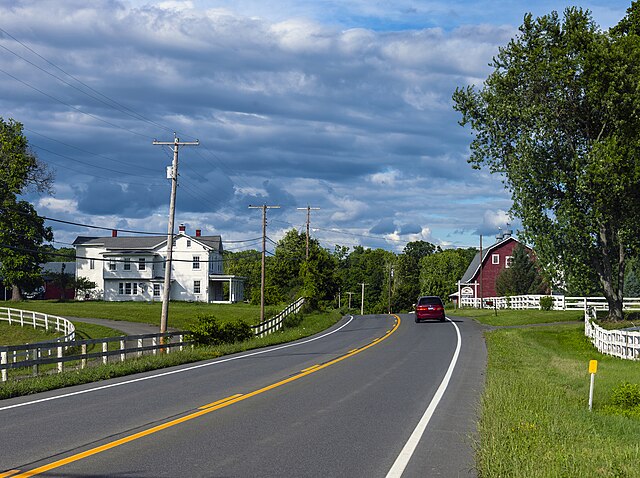
English: This image revisited, from the exact same spot along US 9 in Red Hook, NY, almost nine years afterwards, under fairly similar light and weather conditions. The only real difference is the barn signage, the removal of the trees behind the house and the addition of the fence along the left side of the road, due to a change in farm ownership. |
||
Date | Taken on 10 July 2016 | ||
Source | Own work | ||
Author | Daniel Case | ||
Permission (Reusing this file) |
I, the copyright holder of this work, hereby publish it under the following licenses:
![]() ![]() ![]() This file is licensed under the Creative Commons Attribution-Share Alike 3.0 Unported license.
You may select the license of your choice. |
Camera location | 42° 00′ 26″ N, 73° 51′ 39″ W ![]() | View this and other nearby images on: OpenStreetMap | ![]() |
---|
![]() |
The geographical information in this file was retrospectively estimated.
The location may therefore be somewhat imprecise. Verifying and refining these coordinates is strongly encouraged. |
![]() |
This image has been assessed using the Quality image guidelines and is considered a Quality image.
العربية ∙ جازايرية ∙ беларуская ∙ беларуская (тарашкевіца) ∙ български ∙ বাংলা ∙ català ∙ čeština ∙ Cymraeg ∙ Deutsch ∙ Schweizer Hochdeutsch ∙ Zazaki ∙ Ελληνικά ∙ English ∙ Esperanto ∙ español ∙ eesti ∙ euskara ∙ فارسی ∙ suomi ∙ français ∙ galego ∙ עברית ∙ हिन्दी ∙ hrvatski ∙ magyar ∙ հայերեն ∙ Bahasa Indonesia ∙ italiano ∙ 日本語 ∙ Jawa ∙ ქართული ∙ кыргызча ∙ 한국어 ∙ kurdî ∙ Latina ∙ Lëtzebuergesch ∙ lietuvių ∙ македонски ∙ മലയാളം ∙ मराठी ∙ Bahasa Melayu ∙ Nederlands ∙ Norfuk / Pitkern ∙ polski ∙ português ∙ português do Brasil ∙ qaraqalpaqsha ∙ rumantsch ∙ română ∙ русский ∙ sicilianu ∙ slovenčina ∙ slovenščina ∙ shqip ∙ српски / srpski ∙ svenska ∙ தமிழ் ∙ తెలుగు ∙ ไทย ∙ Tagalog ∙ toki pona ∙ Türkçe ∙ українська ∙ Oʻzbekcha ∙ vèneto ∙ Tiếng Việt ∙ 中文 ∙ 中文(简体) ∙ 中文(繁體) ∙ +/− |
File history
Click on a date/time to view the file as it appeared at that time.
Date/Time | Thumbnail | Dimensions | User | Comment | |
---|---|---|---|---|---|
current | 17:50, 29 January 2018 | ![]() | 4,884 × 3,648 (13.73 MB) | Daniel Case (talk | contribs) | fix cable offset created by overzealous dust spot removal |
05:37, 29 January 2018 | ![]() | 4,884 × 3,648 (13.72 MB) | Daniel Case (talk | contribs) | Clean up remaining dust spots | |
05:24, 24 May 2017 | ![]() | 4,884 × 3,648 (13.63 MB) | Daniel Case (talk | contribs) | {{Information |Description ={{en|1=This image revisited, from the exact same spot along US 9 in Red Hook, NY, almost nine years afterwards, under... |
You cannot overwrite this file.
File usage on Commons
The following 5 pages use this file:
- User talk:Daniel Case
- Commons:Files used on the AARoads Wiki/69
- Commons:Quality images/Subject/Architecture/Transport Infrastructure/Other/Archive 2018 to 2019
- Commons:Quality images candidates/Archives February 01 2018
- File:Bucolic Hudson Valley landscape along US 9 in Dutchess County, nine years later.jpg (file redirect)
File usage on other wikis
The following other wikis use this file:
- Usage on en.wikipedia.org
- Usage on id.wikipedia.org
Metadata
This file contains additional information such as Exif metadata which may have been added by the digital camera, scanner, or software program used to create or digitize it. If the file has been modified from its original state, some details such as the timestamp may not fully reflect those of the original file. The timestamp is only as accurate as the clock in the camera, and it may be completely wrong.
Camera manufacturer | NIKON CORPORATION |
---|---|
Camera model | NIKON D3X |
Exposure time | 1/180 sec (0.0055555555555556) |
F-number | f/6.7 |
ISO speed rating | 100 |
Date and time of data generation | 16:31, 10 July 2016 |
Lens focal length | 58 mm |
Width | 4,884 px |
Height | 3,648 px |
Bits per component |
|
Pixel composition | RGB |
Orientation | Normal |
Number of components | 3 |
Horizontal resolution | 300 dpi |
Vertical resolution | 300 dpi |
Software used | Adobe Photoshop CC 2017 (Windows) |
File change date and time | 12:41, 29 January 2018 |
Exposure Program | Normal program |
Exif version | 2.21 |
Date and time of digitizing | 16:31, 10 July 2016 |
APEX shutter speed | 7.491853 |
APEX aperture | 5.488322 |
APEX exposure bias | 1 |
Maximum land aperture | 4.4 APEX (f/4.59) |
Metering mode | Pattern |
Light source | Fine weather |
Flash | Flash did not fire |
DateTime subseconds | 71 |
DateTimeOriginal subseconds | 71 |
DateTimeDigitized subseconds | 71 |
Color space | Uncalibrated |
Sensing method | One-chip color area sensor |
File source | Digital still camera |
Scene type | A directly photographed image |
Custom image processing | Normal process |
Exposure mode | Auto exposure |
White balance | Manual white balance |
Digital zoom ratio | 1 |
Focal length in 35 mm film | 58 mm |
Scene capture type | Standard |
Scene control | None |
Contrast | Normal |
Saturation | Normal |
Sharpness | Normal |
Subject distance range | Unknown |
Serial number of camera | 5028808 |
Lens used | 28.0-300.0 mm f/3.5-5.6 |
Rating (out of 5) | 0 |
Date metadata was last modified | 07:41, 29 January 2018 |
Unique ID of original document | A35C3838ECD812810F0A45EBAA5B854F |
Structured data
Items portrayed in this file
depicts
10 July 2016
42°0'25.999"N, 73°51'38.999"W
0.00555555555555555555 second
6.7
58 millimetre
100
image/jpeg
- United States photographs taken on 2016-07-10
- License migration redundant
- GFDL
- CC-BY-SA-3.0
- Self-published work
- Files with coordinates missing SDC location of creation
- Media with estimated locations
- Quality images
- Quality images missing SDC depicts
- Quality images of New York (state)
- Quality images of roads and streets in the United States