File:Spital aP Oberweng 107 Prielgruppe.jpg

Original file (6,000 × 4,000 pixels, file size: 5.97 MB, MIME type: image/jpeg)
Captions
Captions
Summary
[edit]DescriptionSpital aP Oberweng 107 Prielgruppe.jpg |
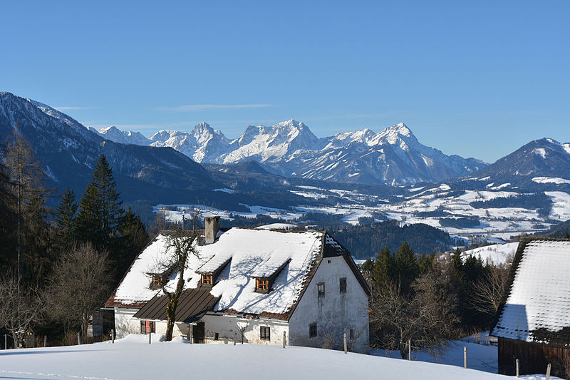
Deutsch: Der Bauernhof Oberfahrenberg in Spital am Pyhrn steht auf einer Höhe von ca. 980 m und gehört den Österreichischen Bundesforsten. Die Berge im Hintergrund gehören zur Prielgruppe des Toten Gebirges. English: The farmhouse Oberfahrenberg in Spital am Pyhrn is located on approximately 980 m a.s.l. and belongs to Österreichische Bundesforste (Austrian Federal Forestries). The mountain ridge in the background is the Prielgroup (part of Totes Gebirge). |
Date | |
Source | Own work |
Author | Isiwal |
Camera location | 47° 41′ 17.98″ N, 14° 23′ 13.74″ E ![]() ![]() | View this and other nearby images on: OpenStreetMap | ![]() |
---|
Licensing
[edit]


- You are free:
- to share – to copy, distribute and transmit the work
- to remix – to adapt the work
- Under the following conditions:
- attribution – You must give appropriate credit, provide a link to the license, and indicate if changes were made. You may do so in any reasonable manner, but not in any way that suggests the licensor endorses you or your use.
- share alike – If you remix, transform, or build upon the material, you must distribute your contributions under the same or compatible license as the original.
![]() |
This image was uploaded as part of Wiki Loves Monuments 2015.
Afrikaans ∙ Alemannisch ∙ العربية ∙ جازايرية ∙ azərbaycanca ∙ Bikol Central ∙ беларуская ∙ беларуская (тарашкевіца) ∙ български ∙ বাংলা ∙ brezhoneg ∙ bosanski ∙ català ∙ čeština ∙ Cymraeg ∙ dansk ∙ Deutsch ∙ Zazaki ∙ Ελληνικά ∙ English ∙ Esperanto ∙ español ∙ eesti ∙ euskara ∙ فارسی ∙ suomi ∙ français ∙ Frysk ∙ Gaeilge ∙ galego ∙ עברית ∙ हिन्दी ∙ hrvatski ∙ magyar ∙ հայերեն ∙ Bahasa Indonesia ∙ Ido ∙ italiano ∙ 日本語 ∙ ქართული ∙ 한국어 ∙ кыргызча ∙ Lëtzebuergesch ∙ latviešu ∙ Malagasy ∙ македонски ∙ മലയാളം ∙ Bahasa Melayu ∙ Malti ∙ norsk bokmål ∙ नेपाली ∙ Nederlands ∙ norsk nynorsk ∙ norsk ∙ polski ∙ português ∙ português do Brasil ∙ română ∙ русский ∙ sicilianu ∙ davvisámegiella ∙ slovenčina ∙ slovenščina ∙ shqip ∙ српски / srpski ∙ svenska ∙ ไทย ∙ Tagalog ∙ Türkçe ∙ українська ∙ اردو ∙ oʻzbekcha / ўзбекча ∙ Yorùbá ∙ 中文 ∙ 中文(中国大陆) ∙ 中文(简体) ∙ 中文(繁體) ∙ 中文(香港) ∙ 中文(臺灣) ∙ +/− |
![]() |
Annotations InfoField | This image is annotated: View the annotations at Commons |
Großer Hochkasten (2389 m)
Feuertalberg (2376 m)
Spitzmauer (2446 m)
Temlberg (2331 m)
Brotfall (2360 m)
Großer Priel (2515 m)
Kreuz (2174 m)
Kirtagmauer (2144 m)
Kleiner Priel (2136 m)
Teufelsmauer (2185 m)
Tamberg (1516 m)
![]() |
This image has been assessed using the Quality image guidelines and is considered a Quality image.
العربية ∙ جازايرية ∙ беларуская ∙ беларуская (тарашкевіца) ∙ български ∙ বাংলা ∙ català ∙ čeština ∙ Cymraeg ∙ Deutsch ∙ Schweizer Hochdeutsch ∙ Zazaki ∙ Ελληνικά ∙ English ∙ Esperanto ∙ español ∙ eesti ∙ euskara ∙ فارسی ∙ suomi ∙ français ∙ galego ∙ עברית ∙ हिन्दी ∙ hrvatski ∙ magyar ∙ հայերեն ∙ Bahasa Indonesia ∙ italiano ∙ 日本語 ∙ Jawa ∙ ქართული ∙ Qaraqalpaqsha ∙ 한국어 ∙ kurdî ∙ кыргызча ∙ Latina ∙ Lëtzebuergesch ∙ lietuvių ∙ македонски ∙ മലയാളം ∙ मराठी ∙ Bahasa Melayu ∙ Nederlands ∙ Norfuk / Pitkern ∙ polski ∙ português ∙ português do Brasil ∙ rumantsch ∙ română ∙ русский ∙ sicilianu ∙ slovenčina ∙ slovenščina ∙ shqip ∙ српски / srpski ∙ svenska ∙ தமிழ் ∙ తెలుగు ∙ ไทย ∙ Tagalog ∙ toki pona ∙ Türkçe ∙ українська ∙ oʻzbekcha / ўзбекча ∙ vèneto ∙ Tiếng Việt ∙ 中文 ∙ 中文(简体) ∙ 中文(繁體) ∙ +/− |
File history
Click on a date/time to view the file as it appeared at that time.
Date/Time | Thumbnail | Dimensions | User | Comment | |
---|---|---|---|---|---|
current | 15:42, 2 September 2015 | ![]() | 6,000 × 4,000 (5.97 MB) | Isiwal (talk | contribs) | User created page with UploadWizard |
You cannot overwrite this file.
File usage on Commons
The following 2 pages use this file:
File usage on other wikis
The following other wikis use this file:
- Usage on de.wikipedia.org
Metadata
This file contains additional information such as Exif metadata which may have been added by the digital camera, scanner, or software program used to create or digitize it. If the file has been modified from its original state, some details such as the timestamp may not fully reflect those of the original file. The timestamp is only as accurate as the clock in the camera, and it may be completely wrong.
Camera manufacturer | NIKON CORPORATION |
---|---|
Camera model | NIKON D7100 |
Exposure time | 1/400 sec (0.0025) |
F-number | f/11 |
ISO speed rating | 100 |
Date and time of data generation | 13:08, 13 January 2015 |
Lens focal length | 38 mm |
Latitude | 47° 41′ 17.98″ N |
Longitude | 14° 23′ 13.74″ E |
City shown | Oberweng |
Horizontal resolution | 300 dpi |
Vertical resolution | 300 dpi |
Software used | Adobe Photoshop Lightroom 5.7 (Windows) |
File change date and time | 16:28, 14 January 2015 |
Exposure Program | Aperture priority |
Exif version | 2.3 |
Date and time of digitizing | 13:08, 13 January 2015 |
APEX shutter speed | 8.643856 |
APEX aperture | 6.918863 |
APEX exposure bias | 0 |
Maximum land aperture | 4.5 APEX (f/4.76) |
Metering mode | Pattern |
Light source | Unknown |
Flash | Flash did not fire, compulsory flash suppression |
DateTimeOriginal subseconds | 90 |
DateTimeDigitized subseconds | 90 |
Color space | sRGB |
Sensing method | One-chip color area sensor |
File source | Digital still camera |
Scene type | A directly photographed image |
Custom image processing | Normal process |
Exposure mode | Auto exposure |
White balance | Auto white balance |
Digital zoom ratio | 1 |
Focal length in 35 mm film | 57 mm |
Scene capture type | Standard |
Scene control | None |
Contrast | Normal |
Saturation | Normal |
Sharpness | Normal |
Subject distance range | Unknown |
GPS tag version | 0.0.2.2 |
Serial number of camera | 4369452 |
Lens used | 18.0-55.0 mm f/3.5-5.6 |
Date metadata was last modified | 17:28, 14 January 2015 |
Unique ID of original document | B7859F17BF7137B32A4FB4E73C081ECA |
Province or state shown | Oberösterreich |
Country shown | Österreich |
IIM version | 4 |
Structured data
Items portrayed in this file
depicts
13 January 2015
47°41'17.981"N, 14°23'13.740"E
0.0025 second
11
38 millimetre
100
image/jpeg
- Cultural heritage monuments in Austria with known IDs
- CC-BY-SA-4.0
- Self-published work
- Images from Wiki Loves Monuments 2015
- Images from Wiki Loves Monuments 2015 in Austria
- Images with annotations
- Images with 10+ annotations
- Quality images
- Cultural heritage monuments in Austria check done
- Uploaded via Campaign:wlm-at
- Quality images from Wiki Loves Monuments Austria 2015
- Quality images of Upper Austria
- Quality images by Isiwal
- Austria photographs taken on 2015-01-13