
File:Skjálfandafljót at Route 1.jpg

Original file (5,760 × 3,840 pixels, file size: 14.08 MB, MIME type: image/jpeg)
Captions
Captions
Summary
[edit]
| Description |
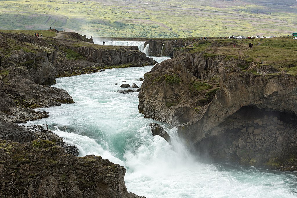
Dansk: Skjálfandafljót ved Hringvegur
Español: Río Skjálfandafljót visto desde la carretera nacional IS-1. En el fondo la Catarata de los Dioses, Región nororiental, Islandia.
Русский: Река Скьяульвандафльоут возле моста на дороге IS-1 в северном регионе Исландии Нордюрланд-Эйстра, сисла Нордюр-Тингейяр. На заднем плане водопад Годафосс.
Polski: Rzeka Skjálfandafljót w pobliżu mostu na drodze krajowej nr 1 w północnej Islandii. W tle widoczny jest spektakularny wodospad Goðafoss.
Português: Rio Skjálfandafljót visto da rodovia nacional IS-1. Ao fundo a Catarata dos Deuses, região Nordeste, Islândia.
Čeština: Peřeje na řece Skjálfandafljót, pohled z hlavní islandské silnice Hringvegur. V pozadí je vidět část impozantního vodopádu Goðafoss.
Deutsch: Der Skjálfandafljót-Fluss an der Ringstraße in Nordisland. Im Hintergrund der Goðafoss-Wasserfall.
Italiano: Il fiume Skjálfandafljót nei pressi della Hringvegur ("strada anello"), la principale strada islandese. Sullo sfondo è visibile la cascata Goðafoss.
Македонски: Реката Скјаулвандафљоут во северен Исланд. Во позадина се гледа величествениот водопад Годафос.
|
|
| Date | ||
| Source | Own work | |
| Author | Villy Fink Isaksen | |
| Permission (Reusing this file) |
I, the copyright holder of this work, hereby publish it under the following license: This file is licensed under the Creative Commons Attribution-Share Alike 4.0 International license.
|
| Camera location | | View this and other nearby images on: OpenStreetMap |
|---|
Assessment
[edit]
|
This image was selected as picture of the day on Wikimedia Commons for 15 August 2016. It was captioned as follows: English: River Skjálfandafljót at Route 1 in northern Iceland. In the background is the spectacular waterfall Goðafoss. Other languages:
Čeština: Peřeje na řece Skjálfandafljót, pohled z hlavní islandské silnice Hringvegur. V pozadí je vidět část impozantního vodopádu Goðafoss. Dansk: Skjálfandafljót ved Hringvegur i baggrunden Goðafoss. Deutsch: Der Skjálfandafljót-Fluss an der Ringstraße in Nordisland. Im Hintergrund der Goðafoss-Wasserfall. English: River Skjálfandafljót at Route 1 in northern Iceland. In the background is the spectacular waterfall Goðafoss. Español: Río Skjálfandafljót visto desde la carretera nacional IS-1. En el fondo la Catarata de los Dioses, Región nororiental, Islandia. Italiano: Il fiume Skjálfandafljót nei pressi della Hringvegur ("strada anello"), la principale strada islandese. Sullo sfondo è visibile la cascata Goðafoss. Polski: Rzeka Skjálfandafljót w pobliżu mostu na drodze krajowej nr 1 w północnej Islandii. W tle widoczny jest spektakularny wodospad Goðafoss. Português: Rio Skjálfandafljót visto da rodovia nacional IS-1. Ao fundo a Catarata dos Deuses, região Nordeste, Islândia. Македонски: Реката Скјаулвандафљоут во северен Исланд. Во позадина се гледа величествениот водопад Годафос. |
This image has been assessed using the Quality image guidelines and is considered a Quality image.
|
File history
Click on a date/time to view the file as it appeared at that time.
| Date/Time | Thumbnail | Dimensions | User | Comment | |
|---|---|---|---|---|---|
| current | 12:58, 25 August 2015 | | 5,760 × 3,840 (14.08 MB) | Villy Fink Isaksen (talk | contribs) | User created page with UploadWizard |
You cannot overwrite this file.
File usage on Commons
The following 33 pages use this file:
- Waterfall
- User:Aristeas/Favorites
- User:Meiræ/15
- User:Miya/sandbox/Candidates2015/Waters
- User talk:Villy Fink Isaksen/Archive 2
- Commons:Featured picture candidates/File:Skjálfandafljót at Route 1.jpg
- Commons:Featured picture candidates/Log/September 2015
- Commons:Featured pictures/Places/Natural/Iceland
- Commons:Featured pictures/chronological/2015-B
- Commons:Picture of the Year/2015/Candidates
- Commons:Picture of the Year/2015/R1/Gallery/2014-B
- Commons:Picture of the Year/2015/R1/Gallery/2015-B
- Commons:Picture of the Year/2015/R1/Gallery/ALL
- Commons:Picture of the Year/2015/R1/Gallery/M09
- Commons:Picture of the Year/2015/R1/Gallery/Waters
- Commons:Picture of the Year/2015/R1/v/Skjálfandafljót at Route 1.jpg
- Commons:Quality images/Subject/Places/Natural structures/archive 2015
- Commons:Quality images candidates/Archives August 28 2015
- Commons:Quality images candidates/Archives August 29 2015
- Template:Potd/2016-08
- Template:Potd/2016-08-15
- Template:Potd/2016-08-15 (cs)
- Template:Potd/2016-08-15 (da)
- Template:Potd/2016-08-15 (de)
- Template:Potd/2016-08-15 (en)
- Template:Potd/2016-08-15 (es)
- Template:Potd/2016-08-15 (hu)
- Template:Potd/2016-08-15 (it)
- Template:Potd/2016-08-15 (ko)
- Template:Potd/2016-08-15 (mk)
- Template:Potd/2016-08-15 (nl)
- Template:Potd/2016-08-15 (pl)
- Template:Potd/2016-08-15 (pt)
File usage on other wikis
The following other wikis use this file:
- Usage on be-tarask.wikipedia.org
- Usage on crh.wikipedia.org
- Usage on cv.wikipedia.org
- Usage on en.wikipedia.org
- Usage on he.wikipedia.org
- Usage on hu.wikipedia.org
- Usage on ka.wikipedia.org
- Usage on ko.wikipedia.org
- Usage on lbe.wikipedia.org
- Usage on mg.wikipedia.org
- Usage on mk.wikipedia.org
- Usage on nn.wikipedia.org
- Usage on os.wikipedia.org
- Usage on pl.wikipedia.org
- Usage on pt.wikipedia.org
- Usage on ru.wikipedia.org
- Usage on ru.wikinews.org
- Usage on sah.wikipedia.org
- Usage on su.wikipedia.org
- Usage on tt.wikipedia.org
- Usage on uk.wikipedia.org
- Usage on vi.wikipedia.org
- Usage on zh.wikipedia.org