
File:Inside the Tarawera rift.jpg

Size of this preview: 800 × 513 pixels. Other resolutions: 320 × 205 pixels | 640 × 410 pixels | 1,024 × 656 pixels | 1,280 × 820 pixels | 3,072 × 1,968 pixels.
Original file (3,072 × 1,968 pixels, file size: 1.87 MB, MIME type: image/jpeg)
Captions
Captions
Add a one-line explanation of what this file represents
Summary
[edit]
| Description |
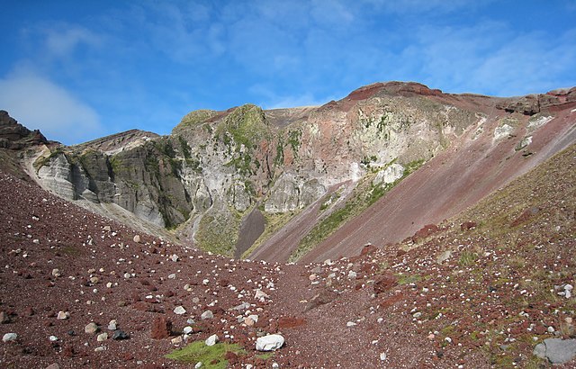
English: View from the middle of the fissure running across the top of Mount Tarawera. This fissure was created when the mountain exploded in 1886. |
| Date | |
| Source | Own work |
| Author | Avenue |
| Other versions | Derivative works of this file: Inside the Tarawera rift - alternative crop.jpg |
| Camera location | | View this and other nearby images on: OpenStreetMap |
|---|
|
| This is a retouched picture, which means that it has been digitally altered from its original version. Modifications: Noise reduced in the sky.
|
This image has been assessed using the Quality image guidelines and is considered a Quality image.
|
Licensing
[edit]
I, the copyright holder of this work, hereby publish it under the following licenses:
This file is licensed under the Creative Commons Attribution-Share Alike 3.0 Unported license.
- You are free:
- to share – to copy, distribute and transmit the work
- to remix – to adapt the work
- Under the following conditions:
- attribution – You must give appropriate credit, provide a link to the license, and indicate if changes were made. You may do so in any reasonable manner, but not in any way that suggests the licensor endorses you or your use.
- share alike – If you remix, transform, or build upon the material, you must distribute your contributions under the same or compatible license as the original.

|
Permission is granted to copy, distribute and/or modify this document under the terms of the GNU Free Documentation License, Version 1.2 or any later version published by the Free Software Foundation; with no Invariant Sections, no Front-Cover Texts, and no Back-Cover Texts. A copy of the license is included in the section entitled GNU Free Documentation License. |
You may select the license of your choice.
File history
Click on a date/time to view the file as it appeared at that time.
| Date/Time | Thumbnail | Dimensions | User | Comment | |
|---|---|---|---|---|---|
| current | 00:47, 22 February 2010 | | 3,072 × 1,968 (1.87 MB) | Avenue (talk | contribs) | Noise reduction on sky. |
| 00:43, 22 February 2010 |  | 3,072 × 1,968 (2.06 MB) | Avenue (talk | contribs) | {{Information |Description={{en|1=View from the middle of the fissure running across the top of Mount Tarawera. This fissure was created when the mountain exploded in 1886.}} |Source={{own}} |Author=Avenue |Date=2009-03-15 |Permission= |ot |
You cannot overwrite this file.
File usage on Commons
The following 6 pages use this file:
- User talk:Avenue/Archives/2010
- Commons:Featured picture candidates/File:Inside the Tarawera rift.jpg
- Commons:Featured picture candidates/Log/March 2010
- Commons:Quality images/Subject/Places/Natural structures/archive 2008 to 2012
- Commons:Quality images candidates/Archives February 2010
- Category:Magmatism of Oceania
File usage on other wikis
The following other wikis use this file:
- Usage on ar.wikipedia.org
- Usage on de.wikipedia.org
- Usage on en.wikipedia.org
- Taupō Volcanic Zone
- Mount Tarawera
- Talk:Mount Tarawera
- Wikipedia:Featured pictures/Places/Landscapes
- Portal:Volcanoes/Selected picture
- Wikipedia:Featured pictures thumbs/22
- Wikipedia:WikiProject Volcanoes/Content
- Wikipedia:Featured picture candidates/Tarawera rift crater
- Wikipedia:Featured picture candidates/March-2010
- Wikipedia:Wikipedia Signpost/2010-03-15/Features and admins
- Portal:Volcanoes/Selected picture/16
- User talk:Avenue/Archive5
- Wikipedia:Picture of the day/October 2011
- Template:POTD/2011-10-21
- Wikipedia:Main Page history/2011 October 21
- User talk:Avenue/Archive2011
- Usage on fr.wikipedia.org
- Usage on he.wikipedia.org
- Usage on it.wikipedia.org
- Usage on no.wikipedia.org
- Usage on pt.wikipedia.org
- Usage on ru.wikipedia.org
- Usage on sl.wikipedia.org
- Usage on sw.wikipedia.org
- Usage on uk.wikipedia.org
- Usage on vi.wikipedia.org
Metadata
Categories:
- Volcanic craters in New Zealand
- Rifts
- Eruption fissures in New Zealand
- Magmatic systems
- Erosion at volcanoes
- Rift zones of Mount Tarawera
- Hydrothermal alteration in New Zealand
- Mineral deposits at volcanoes in New Zealand
- Explosive fissure eruptions
- Igneous intrusions in New Zealand
- Scoria in New Zealand
- Lapilli in New Zealand