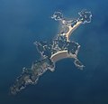
File:Aerial photograph of Gureopdo, South Korea.jpg

Original file (1,350 × 1,290 pixels, file size: 884 KB, MIME type: image/jpeg)
Captions
Captions
Summary
[edit]| DescriptionAerial photograph of Gureopdo, South Korea.jpg |
English: An aerial photograph of the South Korean island Gureopdo (굴업도), taken in September 2019. |
| Date | |
| Source | Own work |
| Author |
Photographer: Mosbatho |
| Attribution (required by the license) InfoField | © Mosbatho / |
InfoField | © Mosbatho |
| Permission (Reusing this file) |
I, the copyright holder of this work, hereby publish it under the following license: This file is licensed under the Creative Commons Attribution 4.0 International license.
|
| Object location | 37° 11′ 08.43″ N, 125° 58′ 22.34″ E | View this and other nearby images on: OpenStreetMap |
|---|

|
This image has been assessed under the valued image criteria and is considered the most valued image on Commons within the scope: Gureopdo island aerial view. You can see its nomination here. |
| Annotations InfoField | This image is annotated: View the annotations at Commons |
Tokisum
File history
Click on a date/time to view the file as it appeared at that time.
| Date/Time | Thumbnail | Dimensions | User | Comment | |
|---|---|---|---|---|---|
| current | 08:48, 2 June 2020 |  | 1,350 × 1,290 (884 KB) | Mosbatho (talk | contribs) | == {{int:filedesc}} == {{Information |Description= {{en|An aerial photograph of the South Korean island Gureopdo, taken in September 2019.}} |Source={{own}} |Date=2019-09 |Author= Photographer: Mosbatho |Permission={{self|Cc-by-4.0}} |other_versions= }} Category:Files by User:Mosbatho |
You cannot overwrite this file.
File usage on Commons
The following 4 pages use this file:
File usage on other wikis
The following other wikis use this file:
Metadata
This file contains additional information such as Exif metadata which may have been added by the digital camera, scanner, or software program used to create or digitize it. If the file has been modified from its original state, some details such as the timestamp may not fully reflect those of the original file. The timestamp is only as accurate as the clock in the camera, and it may be completely wrong.
| Image title |
|
|---|---|
| Copyright holder |
|
| Date and time of data generation | 10:47, 1 September 2019 |
| Short title |
|
| Date and time of digitizing | 10:47, 1 September 2019 |
| DateTimeOriginal subseconds | 49 |
| DateTimeDigitized subseconds | 49 |
Structured data
Items portrayed in this file
depicts
37°11'8.430"N, 125°58'22.339"E
September 2019
image/jpeg
db30da4f0fd0cb23a0f49bb424e7804b71caeadd
905,220 byte
1,290 pixel
1,350 pixel
37°11'8.430"N, 125°58'22.339"E
- Information field template with formatting
- CC-BY-4.0
- Self-published work
- Files with coordinates missing SDC location of creation
- Valued images sorted by promotion date
- Valued images promoted 2021-08
- Valued images missing SDC depicts
- Valued images missing SDC creator
- Files by User:Mosbatho
- Valued images by User:Mosbatho
- Images with annotations
